Feeds:
Posts
Comments

Every so often, we feature seagrass meadows from all over the world. This week, Maria Potouroglou writes about seagrass in Scotland. Maria is a PhD student at Edinburgh Napier University studying carbon sinks in seagrass. Her seagrass adventures started six years ago with projects in Greece, Spain and England.

——————————————————–

[Photos and text by Maria Potouroglou]

Hello Team,

My name is Maria and last February I started my PhD at Edinburgh Napier University looking at the role of seagrasses as coastal carbon sinks under the supervision of Prof Huxham, Dr Diele and Prof Kennedy. Many of you will wonder what a Greek does in Scotland, when seagrasses flourish in the Mediterranean! Well, UK has always been an exotic place to me, and moreover the most abundant meadows of the most widespread seagrass genus occur here, in Scotland.

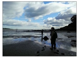
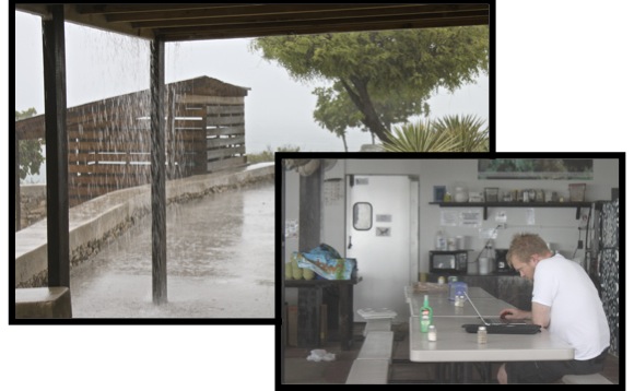
Ecological fieldwork is sometimes fraught with so many obstacles that is hard to imagine why anyone would want to do it. The soft-sediment marine intertidal is one of those habitats that pose a special challenge to the species that live there and the scientists who try to study them. While the species have well adapted to the alternating physical conditions, scientists must fight the tides, which often occur too early or too late and are not sufficiently low (!!) and try to walk on the glue like sediment, which most of the times results to a cream-mud up to the knees, or fully covered waders when gravity prevails over stability.

maria_soctland_fig1

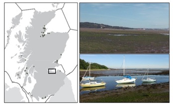
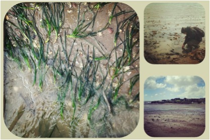
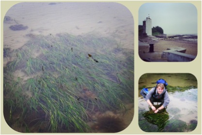
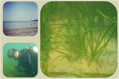
Fieldwork is carried out at Forth Estuary which is located on the east coast of Scotland and contains approximately a quarter of the population of Scotland (~1.3 million people) and a significant proportion of its industry. The Forth estuary is a macrotidal coastal plain estuary, with extensive intertidal mudflats, where Z. noltii forms sparse beds. No dedicated Zostera survey has ever been carried out in the Firth of Forth, while in Scotland’s Marine Atlas of 2011, seagrass beds in the area were completely discarded. So, last May we established ten permanent plots, which we were monitoring biweekly by recording percentage coverage, number of shoots, length of leaves, number of flowers and any signs of disease. I am glad to say that we have a nice dataset of the growth season under our belt. Moreover, we attempted to develop an image analysis technique to actually calculate percentage coverage of the quadrats, instead of relying on our subjective visual estimations.maria_soctland_fig2This technique was also used to map the seagrass meadows in the area. Finally, in late October we took a series of sediment cores, which are being analysed at the moment for total organic matter, organic carbon, and different sources and age of carbon.maria_soctland_fig3Preliminary results have been already presented at a Pecha:Kucha Event (20 slides, 20 seconds per slide – and YES that is a challenge) in Edinburgh, whereas a more detailed talk about our study will be given at the final conference of the COST Action ES0906, “Seagrass productivity: from genes to ecosystem management”, which will be held on March in Portugal.

Seagrass research in Scotland is up and running, so watch this space for more updates of our work.maria_soctland_fig4

Every so often we feature a seagrass meadow from around the world. This week, Richard “RJ” Lilley reports from Samos, a Greek Island in the North Aegean. He is a PhD student at the interdisciplinary Sustainable Places Research Institute at Cardiff University and is exploring seagrass links to food security. He is part of the Seagrass Ecosystem Research Group (www.seagrass.org.uk) and a founding member of Project Seagrass (www.project-seagrass.co.uk).

——————————————————————————

[Photos and text from RJ Lilley]  

Hello again Team Seagrass!

My last notes from the field were 1st June this year when I was reporting from the Turks and Caicos Islands in the Caribbean. Now I am back in Europe once more and into the field again, this time it’s Greece!

I have recently arrived on Samos, a relative small Greek Island (478 km2) located just 1.6km from the Turkish border. A great portion of the island is covered with vineyards (from which muscat wine is made) and the climate so far appears to be living up to pre-trip expectations – “mild rainy winters, and warm rainless summers”.

RJ_Greece1I am working here in collaboration with Archipelagos – Institute of Marine Conservation  exploring the ecosystem service value of seagrass meadows in the the region, and helping to propose potential future management strategies to ensure the conservation of this essential fish habitat.

RJ Greece 3I am proposing multi-method (UVCs, stereoBRUV and Fyke Netting) surveys of the meadows to study fish assemblages and I a hoping to establish some Seagrass-Watch sites across the local island group. This should be a challenge since the dominant seagrass is Posidonia oceanica and there are not as yet pre-determined protocols for this species.

RJ Greece2 I plan to remain here for 12 months and so weather and logistics permitting I should be able to generate quite a comprehensive data-set. Luckily I also have access to Wi-Fi, and so if anyone is keen to follow life in the field check out #teamseagrass or #projectseagrass on instagram for periodic photo updates from life in the field.

I’ll be in touch again with our progress, so watch this space!

RJ


For more information on Archipelagos – Institute of Marine Conservation see here – http://archipelago.gr/en/kentriki-selida-archipelagos/
For more information on the Seagrass Ecosystems Research Group see here – http://www.seagrass.org.uk
For more information on Project Seagrass see here – http://www.project-seagrass.co.uk
For more information on the Sustainable Places Research Institute see here – http://www.cardiff.ac.uk/research/sustainableplaces/
 
And for those Facebook fans out there!
https://www.facebook.com/ProjectSeagrass
https://www.facebook.com/Archipelago.gr
 
And twitter….
@ArchipelagoGr
@ProjectSeagrass

Every so often, we feature a seagrass meadow from around the world. This week, we were lucky enough to hear from Benjamin Jones who’ll be reporting from several seagrass meadows all over the United Kingdom. Ben is an MRes student at Swansea University where he is part of the Seagrass Ecosystem Research Group (www.seagrass.org.uk) and a founding member of Project Seagrass (www.project-seagrass.co.uk).

——————————————————————

Photos & Text by Ben Jones


Over the past 6 months or so, I’ve been out and about around the UK carrying out sample collection for my research project. This involves investigating the role and use of Zostera marina as a biological indicator. The work is being carried out in fulfilment of an MRes degree at Swansea University in collaboration with the Seagrass Ecosystem Research Group.

My project is involves examining the health status of seagrass meadows over a gradient of human induced impacts, with specificity to elevated nutrients and eutrophication. Through collaborations with Seasearch divers, various wildlife trusts as well as research bodies, I have been fortunate enough to visit a number of seagrass meadows around the UK for this research. As a result, the number of locations that have been included in project has steadily risen.
Wales1

The first seagrass meadow I sampled was located at Gelliswick Bay, Wales. This allowed me to get to grips, so to speak, with my methodology, so that I could refine it for future sites. This first sample collection also gave me a bit of a test as to where the seagrass was, which I finally managed to find after an extremely low tide exposed its outer edge. With a good idea of the location and nature of this meadow, I decided to continue sampling at this site for a separate temporal study. Wales2After much red tape and requests for a licence, I was given permission to sample on the Isle of Wight in collaboration with Hampshire and Isle of Wight Wildlife trust who were carrying out mapping for their Solent Seagrass Project. However, this did involve a 3 a.m. start. The joys of working around the tides!

Wales3

With samples being collected from Gelliswick Bay, Skomer Marine Nature Reserve and Porthdinllaen in Wales, Studland Bay, Southend-on-Sea and Helford River in England, the Isle of Man, the Isles of Scilly, the Isle of Wight and Strangford Lough in Northern Ireland, I’ve tried to include as many sites along a gradient of anthropogenic impacts as possible, with Gelliswick Bay and Southend-on-Sea being at the higher end of the scale and Skomer Marine Nature Reserve and the Isles of Scilly at the lower end. Wales4

At each of the sites a number of morphological measurements were taken to assess the habitat and to form the basis of my data. These measurements were shoot density, percentage cover, leaf length, leaf width and number of leaves per shoot. By using these measurements coupled with leaf tissue C, N, N15 and P contents, which is being analysed by IBERS at Aberyswyth University, we hope that it will provide a good level of understanding into the availability of nutrients to the seagrass in the locations we have studied, and for the first time provide a quantitative understanding as to the actual, rather than perceived, risk of the seagrasses to these elevated nutrients.

The next couple of months will be spent sorting through the rest of my samples and finishing of my project, hopefully with some good results to report back with so watch this space.

Every so often (but only as often as we receive contributions) we feature a seagrass meadow from around the world. This week, Richard (RJ) Lilley reports from South Caicos is the Turks and Caicos Islands. He is a PhD student at the interdisciplinary Sustainable Places Research Institute at Cardiff University. He is exploring seagrass links to food security. He is also part of the Seagrass Ecosystems Research Group which are engaged in basic and applied research into the structure, function and resilience of seagrass meadows within a linked social ecological system and the food security support these meadows provide.

—————————————————

  Photos & Text by Richard Lilley.

RJ_caicos1

(click to enlarge)

Hello #teamseagrass,

So here we are based on South Caicos, part of the Turks and Caicos Islands archipelago, working in collaboration with Department of the Environment and Maritime Affairs and the staff at the School of Field Studies. This seagrass research forms part of an interdisciplinary research project between Cardiff University’s Sustainable Places Research Institute and Swansea University’s Department of Biosciences, exploring the ecosystem service value of seagrass meadows in the the region, and helping to propose potential future management strategies to ensure the conservation of this essential fish habitat.

The Turks and Caicos Islands are a British Overseas Territory and lie southeast of the the Bahamas island chain. Whilst being geographically contiguous with the Bahamas they are separate political entities. Here in the Turks and Caicos Islands there is generally a dry and sunny marine tropical climate and but current temperatures here in June are high, averaging around 30℃ and we’ve been receiving some pretty high winds and heavy rainfalls interrupting our survey work somewhat!

RJ_caicos2

(click to enlarge)


Our survey work is multi-method. We’ve laid some Fyke-nets which we check every 12hrs at 06:00 and 18:00 and we’ve been Beach Seining at night from 20:00. Daytime visual censuses have also been undertaken.

RJ_caicos3

(click to enlarge)

Sites were chosen that represented “Lagoon” meadows and “Reef” meadows. Meadows were surveyed using a variety of techniques (visual census, fyke netting and seine netting) to triangulate data and establish robust representations of species assemblages. Species type, size and number were recorded and the data gathered elicited some important relationships between seagrass meadows and species habitat use. This was supported by data accessed and reviewed from local fisheries. Specifically key fisheries (e.g. Grouper, Conch, Grunt) in the Turks and Caicos Islands contributing to major export products and local food supply are supported by seagrass meadows.

We plan to remain here for the whole of June and so weather permitting we should be able  to generate quite a decent data-set. Luckily we also have access to Wi-Fi, and so if anyone is keen to follow our progress check out #teamseagrass on instagram for daily photo updates from life in the field.

For more information on the project see here – http://www.cardiff.ac.uk/research/sustainableplaces/news/step-forward-for-seagrasses.html

For more information on the joint collaboration see here – http://www.seagrass.org.uk

For more information on the Sustainable Places Research Institute see here – http://www.cardiff.ac.uk/research/sustainableplaces/

For more information on Swansea University Biosciences see here – http://www.swansea.ac.uk/biosci/

For more information on the School for Field Stuides see here – http://www.fieldstudies.org/tci

For more information on the Department of the Environment and Maritime Affairs see here – http://www.environment.tc

The WSA website and blog were hacked in mid-January and although no data was lost nor was there any confidential information at risk it caused a bit of a mess. The blog has been reinstated and the main site has been rebuilt from scratch.

Ainsley

« Newer Posts - Older Posts »